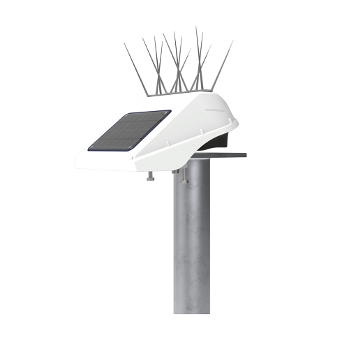


Basetime Locator One Geodetic Monitoring System
Basetime Locator One offers high accuracy structure and soil movements monitoring. Installed on a site or structure, this fully autonomous and power independent GNSS receiver measures horizontal and vertical movements over time, making it the perfect apparatus to monitor accurate positions 24/7 and therefore report key civil works or natural terrain displacements.
Description
Key Points
- Locator One is a high-precision device that autonomously executes deformation measurements at a set time and place and connects regularly to a cloud-based processing and reporting system over LTE-M cellular telecommunications.
- The raw GNSS data is recorded by both base and rover units, transmitted automatically and periodicly to data processing servers that process data and report any movement of the rover unit (the one to measure) against its base (the one setup at a reference position).
- From then, the processed data sub-centimeter precise positioning information can be determined, which is then made accessible through the Basetime dashboard or a user’s preferred information system.
Overview
Locator One units can be used in many monitoring disciplines: soil compacting, landslides, earthquakes or volcanos awareness, bridges, dams, dykes, embankments and causeways. Engineered to work in full autonomy, the units do not need to be visited or plugged in any way, doing their work flawlessly, thanks to their solar panel, battery and cellular datalink.
Basetime Locator One uses a GNSS sensor to monitor and present the horizontal and vertical movements of the unit itself, but also of the ground level below it, by using a RADAR sensor aimed downwards to measure the height and thickness of anything below, be it water, sand or gravel.
In the case of soil settlement monitoring, the automated sensor measures the exact position of the top of a settlement rod with the precision of – at most – 5mm in the Z direction and 3mm in the X-Y direction. By using these observations, calculations can be made to provide the accurate information you need, such as the settlement of the original ground level, and the added sand layers placed on top of it.
In other cases, when Locator One is placed on a structure requiring position monitoring, nothing else is required: if it moves in any direction, the dashboard will see where and by what horizontal and vertical distance.
Compared to the traditional method of collecting geodetic observations, the automatic device offers numerous advantages. In addition to giving precise GNSS measurements and measuring the distance to ground with radar, the Locator One guarantees: accuracy, safety, predictability and sustainability.
Accuracy
Locator One measures with 5mm of accuracy in the Z direction and 3mm in the X-Y direction (95% of the time). Locator One autonomous devices guarantees consistent data and another 95% uptime is maintained, assuming completely unobstructed visibility from 10 degrees above the horizon is provided and nothing obstructs its solar panel’s sun exposure.
Safety
Locator One improves construction site safety by eliminating unnecessary human involvement, in-person site visits and use of vehicles other than to install or remove the units.
Predictability
The collection and calculation of accurate data on pre-defined timestamps offers prediction of subsidence and settlement, allowing any precautionary action to be taken.
Sustainability
Powered by solar energy and a super capacitor, Locator One functions autonomously and eliminates the need for maintenance visits, reducing its environmental footprint to almost nothing.
Who Can Benefit?
- Civil Security agencies
- Construction enterprises
- Engineering firms
- Coast Guards and Maritime operators
- Geodetic and geotechnical experts
- Transportation departments
- Bridge and port authorities
- Power Utilities for dams and water retention monitoring
What’s Included?
- Autonomous, precise GNSS-based monitoring system
- Backend database, including geodetic and other statistic algorithms, improving the precision of measurements
- Basetime dashboard or via API for custom user data automation
How Does the Device Work?
Installation
One or more Locator One units are installed on the structure or ground to be nonitored. One unit is located at a stable location from which all movements and displacemant vectors will be monitored. This base unit must be placed no more than 4km from any of the rover units measuring their position from it. To summarize, at least two units are required on a project: one stable and one or many to be monitored.
Monitoring
The devices send their observations and metadata through an IoT network to our cloud. After geodetic adjustments and calculations, the data is delivered.
Dashboard
Results are displayed on the Basetime dashboard that is accessible from a web browser connected to the Internet, reaching Basetime operated cloud service. Reporting is offered with graphs or raw displacement data can be downloaded in text CSV or Excel formats. The dashboard is also used to configure projects, users, assign units to them and program their exact behavior such as the times of day measures are performed.
Pay per use
The data transfers (one or many per day) are paid based on a credits mechanism. If Locator One units are not assigned any measurement task, there is no usage fee associated to them. Users can buy processing credits from us along a few bundled packages.
Video
Why Buy from Us?
In business since 2004, Canal Geomatics is an authorized dealer for Basetime and has established itself as an industry-leading distributor of high-precision positioning products in North America. Our mission is to find the best solution for each unique application and extend premium support to ensure the long-term success of our customers. We offer both volume and reseller discounts for the majority of our product lines.
Ordering
The Locator One from Basetime is available through Canal Geomatics. If you would like more information about this product, please feel free to get in touch with us by completing the Request Pricing form.
Datasheets
![]()
VIEW DATASHEET
![]()
Basetime-Locator-One-Monitoring-precision.pdf
![]()
Bridge-monitoring-Haringvlietbrug_ENG.pdf
![]()
Land-slide-Vorarlberg_ENG.pdf
![]()
Maximize-measurement-efficiency-and-accuracy.pdf
![]()
Parvamoti-Product-sheet_ENG.pdf
![]()
PPM-leaflet.pdf