Data Imaging Company Chooses Piksi Multi RTK GNSS Receiver for Centimeter-Level GNSS in High-Precision Drones
Overview
Skycatch is an industry leading data and data-imaging company focused on indexing and extracting critical information from the physical world using a combination of drones, edge computing, software, and artificial intelligence. Their products are built for construction and inspection; they deliver the highest accuracy, consistency, and reliability to help people operate faster, safer and smarter.
Challenge
Construction, mining and energy are some of the most demanding industries, requiring ongoing assessment to ensure projects and objectives are on-track, on-time and ultimately on-budget. Traditional assessments of progress are either based on the experience and best guesses of crew members on the ground, yielding reports from the field that are often out-of-date and inaccurate. Surveying by unmanned aerial vehicles (UAVs) allows for more accurate assessments but has traditionally encountered limitations including requiring the laborious implementation of ground control points (GCPs) which often negates the efficiency that would have been gained by using UAVs.
Skycatch overcame such obstacles for its customers by rethinking UAV technology, base station capabilities and data processing. It eliminated the need for GCPs and developed smart autonomous drones that could fly data collection missions on their own with little operator input, allowing project managers to obtain fast and reliable centimeter accurate results to make much more informed decisions without leaving job sites.

Photo Credit: Skycatch
Solution
To meet its customers’ accuracy needs, Skycatch knew that real-time kinematics (RTK) GNSS technology would be required. When it first started experimenting with RTK, Skycatch utilized a low cost, single frequency receiver and quickly discovered that dual frequency would be necessary to deliver faster fixes and longer baselines. When Swift Navigation launched its Piksi Multi dual-band, multi-constellation RTK receiver — that delivered the less than 5 cm accuracy Skycatch required at a price point that was a fraction of comparable receivers — Skycatch integrated Swift’s hardware into their solution. During testing, Piksi Multi was able to deliver an RTK fix in a matter of seconds vs. minutes, enabling a flight-to-processing turn around time of 30 minutes for a 25 acre site. Skycatch knew it would be a critical component to its Edge1TM intelligent base station.
In addition to its product features, Swift Navigation as a company played a role in Skycatch’s decision to utilize Piksi Multi. The San Francisco-based Swift team was a responsive resource, answering questions not only about Swift’s products but also about satellite systems and integration into Skycatch’s solutions — helping to streamline their product development process. Swift’s applications engineering team continues to be a helpful technical resource to Skycatch as it innovates on its product offerings.
Currently, Piksi Multi can be found within Edge1 — the market-first combination GNSS base station and field processing unit. Edge1 provides easy setup on site via self-positioning, plus a simple-to-use processing app to deliver high-accuracy point clouds with ease.
“Swift Navigation has established itself as a clear leader and innovator with their low cost high-precision GNSS solution. Our customers require reliable, fast, and accurate results and Swift’s technology enables our high-precision products deliver more precise data without traditional ground control points.”
– Christian Sanz, CEO and Founder of Skycatch
Results
Skycatch customers use the Skycatch drone mission planning app to plan data collection missions with the The Explore1 high-precision drone. Explore1 autonomously flies the area mapped in the app and captures high-resolution imagery which is then processed on site with Edge1’s on-board image processing. Edge1 works anywhere in the world, even without internet connectivity. Images are processed into centimeter-accurate orthomaps and 3D models from the cloud, where users analyze data in the Skycatch web viewer or export files to use with other software like Autodesk or ArcGIS.
Whether it’s time equaling money or accuracy leading to efficiency, benefits abound for Skycatch customers on industrial sites. With accurate measurements during the excavation phase, there is visibility to how much digging is really happening. With accurate measurements during construction, planners can monitor daily progress and plans can be updated to fit reality. Some Skycatch customers are able to complete projects 25% faster. These efficiencies help to complete build-out phases more rapidly, allowing them to start their next project sooner and ultimately win more business.
This case study was originally posted by Swift Navigation. Click here to see the full case study.
About Swift Navigation
Swift Navigation provides precise positioning solutions for automotive, autonomous vehicle, mobile and mass market applications.
Since its founding in 2012, Swift has evolved from creating the industry’s first low-cost, high-accuracy, real-time kinematic (RTK) GPS receiver to delivering an ecosystem of GNSS positioning solutions for autonomous applications.
About Canal Geomatics
Canal Geomatics Inc. is the industry-leading distributor of high-precision positioning solutions in North America, specializing in automotive, airborne, rail, marine, UAS and robotics. Our mission is to find the best solution for each unique application and extend premium support to ensure the long-term success of our customers. Canal Geomatics is a proud supplier of precise positioning products from Swift Navigation.
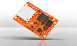
Piksi Multi RTK GNSS Receiver
Piksi Multi is a multi-band, multi-constellation RTK GNSS receiver board that provides centimeter-level accurate positioning at a low cost. Being multi-band means fast convergence times measured in seconds, not minutes. Access to multiple satellite constellations improves availability, reliability and range between base and rover. With Piksi Multi, you’ll benefit from faster system start times and reacquisition, critical to robotic systems. It’s easy to get started with a comprehensive Piksi Multi Evaluation Kit.
Looking for a Price?
If you can’t find the product you’re looking for, or have a question about any of the products we carry, call us at 1-888-595-5015 and we’ll help you find what you need, including products not listed on our website.