NovAtel CPT7700 GNSS + INS Receiver
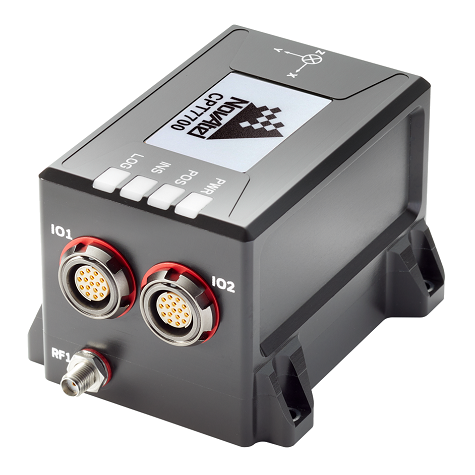
The NovAtel CPT7700 is an ultra-compact, light-weight, single-antenna enclosure with SPAN GNSS+INS technology delivering 3D positioning, velocity and attitude.
Description
Overview
The CPT7700 is an ultra-compact enclosure containing an OEM7700 receiver from Hexagon | NovAtel and a high-performing Honeywell HG4930 Micro Electromechanical System (MEMS) Inertial Measurement Unit (IMU) to support leading-edge SPAN technology from NovAtel in an integrated, single enclosure solution. The absolute accuracy of Global Navigation Satellite System (GNSS) positioning and the stability of Inertial Measurement Unit (IMU) gyro and accelerometer measurements are deeply coupled to provide an exceptional 3D navigation solution with reliable velocity and attitude measurements. The internal OEM7700 receiver offers simultaneous tracking of multi-GNSS signals across all frequencies.
It provides tactical grade performance for unmanned vehicles, mobile mapping and other commercial and military guidance applications. The CPT7700 is a small, lightweight and low-power solution with multiple communication interfaces for easy integration on various platforms. The deep coupling of GNSS and INS measurements enhances satellite tracking and enables the most continuous positioning possible.
The deep coupling of the GNSS and IMU measurements delivers the most satellite observations and the most accurate, continuous solution possible. Further, the CPT7700 is comprised entirely of commercial components, simplifying export restrictions involved with traditional GNSS+INS systems.
CPT7700 provides your choice of accuracy and performance, from decimeter to RTK-level positioning. For more demanding applications, Inertial Explorer post-processing software can be used to post-process the real-time SPAN GNSS+INS solution to provide the system’s highest level of accuracy.
SPAN GNSS+INS technology brings together two different but complementary technologies: Global Navigation Satellite System (GNSS) positioning and Inertial Navigation System (INS). The absolute accuracy of GNSS positioning and the stability of Inertial Measurement Unit (IMU) gyro and accelerometer measurements are deeply coupled to provide an exceptional 3D navigation solution that is stable and continuously available, even through periods when satellite signals are blocked.
Benefits
- High performance SPAN GNSS+INS solution
- Small, low-power, all-in-one GNSS+INS enclosure
- Easy integration into space and weight constrained applications
- Commercially exportable system
- Rugged design ideal for challenging environments
- Enhanced connection options including serial, USB, CAN and Ethernet
- Future-proof for upcoming GNSS signal support
Features
- MEMS gyros and accelerometers
- Small size, rugged and lightweight
- Dedicated wheel sensor input
- TerraStar Correction Services supported over multi-channel L-Band and IP connections
- Advanced interference mitigation features
- SPAN GNSS+INS capability with configurable application profiles
- 16 GB of internal storage
- Four receiver status LEDs
Technical Specifications
| Signal Tracking | |
| GPS: | L1 C/A, L1C, L2C, L2P, L5 |
| GLONASS: | L1 C/A, L2 C/A, L2P, L3, L5 |
| Galileo: | E1, E5 AltBOC, E5a, E5b, E6 |
| BeiDou: | B1I, B1C, B2I, B2a, B2b, B3 |
| QZSS: | L1 C/A, L1C, L2C, L5, L6 |
| NavIC (IRNSS): | L5 |
| SBAS: | L1, L5 |
| L-Band (Primary RF only): | Up to 5 channels |
| Physical | |
| System Type: | Enclosed with IMU GNSS+INS enabled |
| Dimensions: | 90 mm x 60 mm x 60 mm |
| Weight: | 500 g |
| Power Consumption: | 9 W (typical) |
| Input Voltage: | +9 to +32 VDC |
| Performance | |
| Single Point L1: | 1.5 m (RMS) |
| Single Point L1/L2: | 1.2 m (RMS) |
| SBAS: | 60 cm (RMS) |
| DGPS: | 40 cm (RMS) |
| TerraStar-L: | 40 cm (RMS) |
| TerraStar-C PRO: | 2.5 cm (RMS) |
| TerraStar-X: | 2.0 cm (RMS) |
| RTK: | 1 cm + 1 ppm |
| IMU Raw Data Rate: | 100 Hz or 400 Hz |
| Gyroscope | |
| Technology: | MEMS |
| Input Rate (max): | ±325&/S |
| Accelerometer | |
| Technology: | MEMS |
| Range: | ±20 g |
| Environmental | |
| Operating Temperature: | -40°C to +71°C |
| Storage Temperature: | -40°C to +85°C |
| Humidity: | 95% non-condensing |
| Submersion: | 2 m for 12 hours (IEC 60529 IP68) |
| Water: | MIL-STD-810H, Method 512.6 |
| Dust: | MIL-STD-810H, Method 510.7 |
| Operating Vibration Random: | MIL-STD-810H, Method 514.8, Category 24, 7.7 g RMS |
| Sinusoidal: | IEC 60068-2-6 |
| Operating Acceleration: | MIL-STD-810H, Method 513.8, Procedure II (G Loading – 15 g) |
| Operating Bump: | IEC 60068-2-27 Ea (25 g) |
| Operating Shock: | MIL-STD-810H,Method 516.8, Procedure 1, 40 g, 11 ms terminal sawtooth |
Warranty
NovAtel products come with a one-year warranty. The warranty, provided by NovAtel, covers any product which does not materially conform to NovAtel’s specifications or that is significantly defective in materials or workmanship, for a period of 12 months from the date of shipment. Accessories come with a similar 90-day warranty. NovAtel’s Extended Warranty Program provides the option to increase the duration of the warranty by an additional 12 or 24 months. The warranty is covered in more detail in the NovAtel Warranty and Return Policies page.
Why Buy from Us?
In business since 2004, Canal Geomatics is an authorized dealer for NovAtel and has established itself as an industry-leading distributor of high-precision positioning products in North America. Our mission is to find the best solution for each unique application and extend premium support to ensure the long-term success of our customers. We offer both volume and reseller discounts for the majority of our product lines.
Ordering
The CPT7700 GNSS/INS receiver from NovAtel is available through Canal Geomatics. If you would like more information about this product, please feel free to get in touch with us by completing the Request Pricing form.

