Locator One: Advanced GNSS-Based Monitoring System
Precision Movement Monitoring for Critical Infrastructure and Construction Projects
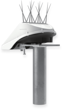
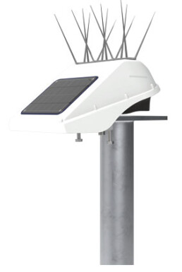
Basetime Locator One offers high accuracy structure and soil movements monitoring. Installed on a site or structure, this fully autonomous and power independent GNSS receiver measures horizontal and vertical movements over time, making it the perfect apparatus to monitor accurate positions 24/7 and therefore report key civil works or natural terrain displacements.
High-Precision, Sustainable Monitoring
Locator One offers a cutting-edge approach to movement detection by combining high-precision GNSS and radar technologies. By delivering reliable geodetic data with minimal environmental impact, it represents a new standard in monitoring systems for sectors where accuracy, safety, and sustainability are paramount.
Unmatched Accuracy
Locator One measures with 5mm of accuracy in the Z direction and 3mm in the X-Y direction (95% of the time). Locator One autonomous devices guarantees consistent data and another 95% uptime is maintained, assuming completely unobstructed visibility from 10 degrees above the horizon is provided and nothing obstructs its solar panel’s sun exposure.
Predictability for Proactive Managements
Data is collected and processed at predefined intervals, enabling users to predict subsidence, settlement, and other movement trends over time.
The predictability of Locator One’s data allows project managers and engineers to take proactive steps to prevent or mitigate potential issues, safeguarding infrastructure and surrounding environments.
Enhanced Safety for Workers and Sites
Locator One significantly enhances construction site safety by minimizing the need for on-site human presence and reducing vehicle usage. This autonomous GNSS-based monitoring system operates with subcentimeter precision, delivering accurate data without the necessity for frequent manual checks. Its self-sufficient design, powered by solar energy and a supercapacitor, further contributes to safety by eliminating the risks associated with regular maintenance visits.
Environmentally Friendly and Sustainable
Locator One’s design incorporates solar energy and a super capacitor, enabling autonomous operation without frequent maintenance visits. This self-sufficient system significantly reduces CO₂ emissions associated with its use, aligning with eco-friendly project objectives and minimizing its carbon footprint.
How Locator One Works
1. Installation
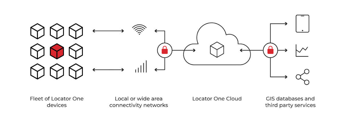
One or more Locator One units are installed on the structure or ground to be nonitored. One unit is located at a stable location from which all movements and displacement vectors will be monitored. This base unit must be placed no more than 4km from any of the rover units measuring their position from it. To summarize, at least two units are required on a project: one stable and one or many to be monitored.
2. Monitoring
The devices send their observations and metadata through an IoT network to our cloud. After geodetic adjustments and calculations, the data is delivered.
3. Data Delivery
Results are displayed on the Basetime dashboard that is accessible from a web browser connected to the Internet, reaching Basetime operated cloud service. Reporting is offered with graphs or raw displacement data can be downloaded in text CSV or Excel formats. The dashboard is also used to configure projects, users, assign units to them and program their exact behavior such as the times of day measures are performed.
4. Pay per use
The data transfers (one or many per day) is paid based on a credits mechanism. If Locator One units are not assigned any measurement task, there is no usage fee associated to them. Users can buy processing credits from us along a few bundled packages.
Applications and Use Cases
- Civil Security agencies: Civil security agencies can enhance their infrastructure monitoring by utilizing Locator One’s autonomous GNSS-based system, enabling proactive detection of structural shifts and potential hazards.
- Construction and infrastructures sites: Track and monitor settlement on construction sites, bridges, dams, and other critical structures.
- Power Utilities for dams and water retention monitoring: enhance dam safety by employing Locator One’s autonomous GNSS-based monitoring system, enabling precise detection of structural deformations and water retention anomalies, thereby facilitating proactive maintenance and risk mitigation.
- Industrial sites: Automate the monitoring of industrial structures to ensure safety and compliance
- Environmental Monitoring: Locator One enhances environmental monitoring by providing precise, real-time data on land movement and structural changes. Additionally, its solar-powered design aligns with sustainable practices, supporting eco-friendly monitoring initiatives.
Consultancy and Support
Beyond delivering the Locator One system, Canal Geomatics and Basetime offer expert consultancy services to help you integrate and optimize this technology within your projects. With nearly 15 years of experience in GNSS, geodesy, and IoT, our team is here to help you maximize the value of Locator One.
[testimonialslider id=’1′]